1½-Mile Reach EE/CA and Removal Action
The next 1½ miles of the river are located in an area with residential, commercial, industrial and undeveloped/recreational properties. In all, there are approximately 40 residential properties located within or adjacent to the floodplain. Approximately 1,500 feet of this reach was channelized by the city and the USACE in the 1940s and three former oxbows are within this stretch of the river. In the first mile, the riverbanks are generally steep and the floodplain narrow. In the last ½ mile, the riverbanks are relatively low, resulting in a broad floodplain. The 1½-Mile Reach ends at the confluence of the East and West Branches of the Housatonic River.
The average concentration of PCBs in the surficial sediments (0 to1 foot depth) was 21 ppm and the average concentration of PCBs in sediments at all depths was 29 ppm. For the riverbanks, the average concentration of PCBs in the top foot was approximately 23 ppm and the average concentration of PCBs in the top 3 feet was 40 ppm.
EPA initiated the cleanup of the sediment and riverbanks in this 1½-Mile Reach under the Consent Decree in October 2002. GE has agreed to reimburse EPA as part of a cost-sharing arrangement. As an example of how the cost-sharing agreement works, if the selected cleanup alternative costs a total of $85 million, GE will pay about $50 million and EPA will pay about $35 million (see the Consent Decree language under “Cleanup Agreements” for more details).

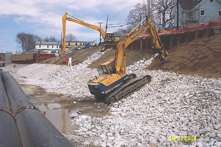
EPA completed excavation activities in March of 2006 and substantially completed the restoration activities by the end of 2006. EPA employed a combination of the “dry excavation” technique used by GE and discussed above and a gravity-fed bypass system. The bypass system consisted of a temporary dam (which was installed approximately 1,400 feet downstream from the Lyman Street Bridge) that diverted the river flow into two 54-inch movable HDPE pipes. The pipes were placed along one side of the river channel while the riverbed sediment and riverbank soil on the other side were removed and backfilled. The pipes were then moved to the remediated side of the river and the process was repeated. Additional sections of pipe were added to the two 54-inch pipe extending the system as the removal and restoration progressed downstream.
In total, approximately 91,700 cubic yards (CY) of contaminated sediment and riverbank material was removed and disposed of as part of the 1½-Mile Reach Removal Action. Approximately 7,000 CY of this material was impacted by non-aqueous phase liquids (NAPL). 50,750 CY of the contaminated material was disposed of in GE’s On-Plant Consolidation Areas and the remainder of the contaminated material, including all of the NAPL-impacted material, was disposed of at licensed off-site disposal facilities.
In June of 2007, EPA sampled river sediment, benthic invertebrates, and fish from three locations in the 1½-Mile Reach. Sediment and benthic invertebrate tissue were analyzed for PCBs, and the individual fauna in the invertebrate and fish samples were identified and enumerated. The results were compared to samples collected at the same locations in 2000, prior to the start of remediation.
Sediment PCB concentrations in 2007 were reduced from the pre-remediation concentrations by approximately 99%, indicating that the initial remediation was successful. The decrease in sediment PCB contamination was reflected in the 99.5% decrease in benthic invertebrate tissue PCB concentrations. Benthic invertebrate populations showed an increase in diversity, abundance, and biomass at all locations post remediation, with a marked increase in pollution-intolerant species. The results of the fish sampling indicated the presence of a diverse and abundant post-remediation fish population in keeping with the expected fish community composition, with noticeably greater fish presence in the vicinity of stone structures provided as part of habitat restoration in the river channel.
In 2008, EPA finalized an Interim Post-Removal Site Control (PRSC) Plan. In early 2008, GE assumed responsibility and is currently conducting all required post-removal site control activities (e.g., inspections, monitoring and maintenance activities) pursuant to the Interim PRSC Plan.
http://www.epa.gov/region01/ge/thesite/1andhalfmile-reports.html
